


January 01, 2013
Isn't it Nice
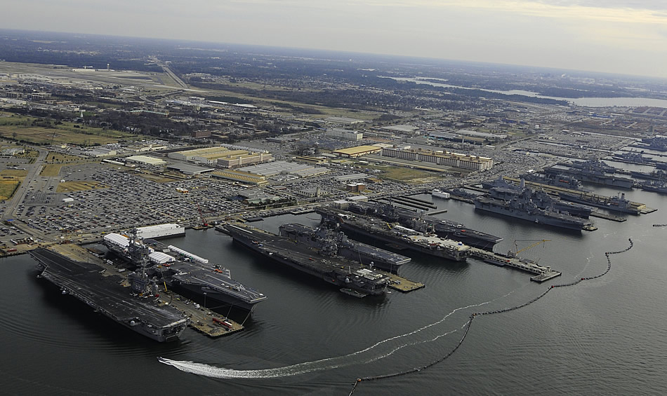
...that we closed down Charleston, Staten Island and Roosevelt Roads so that we can have 9 carriers in one spot for an ice-cream social?
Comments are disabled.
Post is locked.
Norfolk 4 days ago...it's not much emptier now.
This is not going to be popular here in Virginia, but we REALLY need to disperse the fleet. Charleston, Pensacola, and for smaller ships Wilmington, need to be brought on line to spread out the targeting problem for potential enemies. As it stands now, even without someone sailing a nuke in a container into the harbor, a few mines secreted surreptitiously could cause major mayhem for the USN.
Posted by: The Brickmuppet at
08:25 PM
| Comments (8)
| Add Comment
Post contains 103 words, total size 1 kb.
1
I second that argument. What would happen if an LNG tanker made a wrong turn?
Posted by: jcarlton at Tue Jan 1 23:28:35 2013 (i0RQw)
2
Funny, the first thing that came into my mind when I saw that picture was not Look at all 'em carriers! but It's so flat! I have more elevation from my front yard to the back than that photo shows from coastline to horizon.
Posted by: Pixy Misa at Thu Jan 3 02:16:57 2013 (PiXy!)
3
Well, the horizon is actually the Chesapeake Bay. The pic is looking east over a spit of land separating the Elizabeth River from the bay. This area is really flat but that tounge of land is unusually so.
Posted by: The Brickmuppet at Thu Jan 3 03:28:23 2013 (C3KwS)
4
Also remember that this whole area was ground flat by glaciers during the last ice age.
Posted by: Steven Den Beste at Thu Jan 3 07:17:59 2013 (+rSRq)
5
??? Maybe during a previous ice age, Steven, but the last glacation, the Wisconsin, didn't get further than the terminal morraines - from Nantucket to the Ohio to the upper Midwest.
My understanding is that the southern Chesapeake Bay is largely sedimentary, not glacial in origin. They were indirectly created by glaciation, but mostly because of runoff from distant upstream glacial masses, not the actual glaciers themselves.
My understanding is that the southern Chesapeake Bay is largely sedimentary, not glacial in origin. They were indirectly created by glaciation, but mostly because of runoff from distant upstream glacial masses, not the actual glaciers themselves.
Posted by: Mitch H. at Thu Jan 3 10:40:53 2013 (jwKxK)
6
Actually the farthest south they got on the eastern seabosard was Pennsylvania.
The area in the picture is just silt deposited by the rivers that join in the Roads and sand deposited by the ocean. It's like a delta but the main channels are very wide and don't move around.
During the ice age the James, Elizabeth and Pagan rivers merged in what is now the roads and went down rapids into the Potomac which was at the bottom of the then steep valley/canyon that eroded its way through the meteor crater we now call the Chesapeake Bay. That gorge went almost to the then coast (near the continental shelf). This area used to be very hilly on the edge of a canyon but it is all silted up now because of rising sea levels resulting from GLOBAL WARMING which in addidtion to making Al Gore rich causes boring landscapes.
Posted by: The Brickmuppet at Thu Jan 3 11:01:06 2013 (vp6an)
7
Oops. Mitch beat me to it while I was looking for a map.
Posted by: The Brickmuppet at Thu Jan 3 11:02:36 2013 (vp6an)
8
I stand corrected.
Posted by: Steven Den Beste at Thu Jan 3 11:19:06 2013 (+rSRq)
25kb generated in CPU 0.0267, elapsed 0.1226 seconds.
68 queries taking 0.1053 seconds, 220 records returned.
Powered by Minx 1.1.6c-pink.
68 queries taking 0.1053 seconds, 220 records returned.
Powered by Minx 1.1.6c-pink.

