


October 26, 2012
UNEXPECTEDLY....
....Oregon is in the crosshairs. It looks like Steven's smugness has jinxed Oregon and doomed us all.
In all seriousness, this really does have the potential to be a first class calamity.
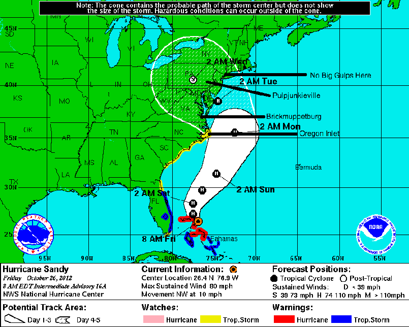
This thing is a queer storm to begin with because it is so damned big, tropical storm force winds extend over 200 miles from its eyewall as I type this.
The big worry is up north. If, as expected, it turns into a hybrid nor'easter and then hits a cold front it will develop along very similar lines to the great 1888 blizzard. Its current track looks to bring utter disaster to central PA, but if it hits just south of New York it will push a maximum amount of surge into the Hudson.
Thus the nightmare 'hurricane hits NYC just right' scenario is still a possibility. The surge from this storm is likely to be much greater than a normal storm of its wind speed due to its great size and in any event these "Frankenstorms" are fiendishly difficult to predict (very few have happened).
Down here in Virginia, a 50 mile difference in the things track east tor west will make the difference between a rainy windy day and actual excitement.
For my part the generator is tested and I'll be getting additional water and petrol on the way home from school. While I don't expect a great deal of major damage around here except, perhaps, at the oceanfront, I do expect to loose power and web access, possibly for several days.
Comments are disabled.
Post is locked.
This thing is a queer storm to begin with because it is so damned big, tropical storm force winds extend over 200 miles from its eyewall as I type this.
The big worry is up north. If, as expected, it turns into a hybrid nor'easter and then hits a cold front it will develop along very similar lines to the great 1888 blizzard. Its current track looks to bring utter disaster to central PA, but if it hits just south of New York it will push a maximum amount of surge into the Hudson.
Thus the nightmare 'hurricane hits NYC just right' scenario is still a possibility. The surge from this storm is likely to be much greater than a normal storm of its wind speed due to its great size and in any event these "Frankenstorms" are fiendishly difficult to predict (very few have happened).
Down here in Virginia, a 50 mile difference in the things track east tor west will make the difference between a rainy windy day and actual excitement.
For my part the generator is tested and I'll be getting additional water and petrol on the way home from school. While I don't expect a great deal of major damage around here except, perhaps, at the oceanfront, I do expect to loose power and web access, possibly for several days.
Posted by: The Brickmuppet at
11:01 AM
| Comments (1)
| Add Comment
Post contains 257 words, total size 2 kb.
1
I live much further inland than you in VA, but updated storm tracks keep drifting west, so even I'm starting to be concerned. Stay safe out there!
Posted by: Siergen at Fri Oct 26 14:45:39 2012 (Bv5ty)
21kb generated in CPU 0.0221, elapsed 0.1369 seconds.
69 queries taking 0.0988 seconds, 203 records returned.
Powered by Minx 1.1.6c-pink.
69 queries taking 0.0988 seconds, 203 records returned.
Powered by Minx 1.1.6c-pink.

