


August 31, 2008
Hurricane Week
UPDATE: Bumped to top
This is very nearly a worst case track.
It looks like NOLA is going to be in the danger quadrant and winds will be blowing into New Orleans from Lake Ponchartrain. This is a far, more direct hit than the city got during Katrina and will put maximum stress on the levees. Weather Nerd has more.
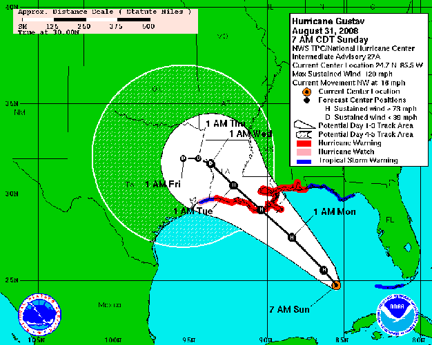
A better idea of the windspeeds can be seen below click here for full size.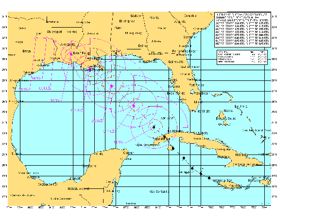
Information Dissemination has a post on the Navy side of the disaster preparations, note that the main difference between this and 2005 is that the current governor of Louisiana is competent and also unlikely to deny them entry and Mayor Nagin is not being an ass. Having learned his lesson, he has ordered a timely evacuation this time and seems to be implementing a real evacuation plan.
Regards the Hospital Ships, Mercy is still in Paupa New Guinea but Comforts last publicly acknowledged location was Baltimore.
Excerpted...emphasis mine.
This has every indication of being at least as bad as 2005.
If you want to help, either in person or by donation, Rambling Rebuilder, who spent much of 2005/2006 doing relief and recovery efforts along the Gulf Coast sends these helpful links.
.
Southern Baptist Disaster Relief...are acknowledged as the experts in Hurricane relief in the southeast.
Habitat for Humanity...helps out with the aftermath of these things.
Samaritans..don't get much attention, but Rambling Rebuilder says they were very heavily engaged and helpful in the area after the 2005 calamity.
These are the ones he saw that were most visible.
There is also a big list of relief NGO's on this page.
If by some bizarre chance you are reading this and are in the above indicated path....get off the damn computer and leave!
Meanwhile....
This is very nearly a worst case track.
It looks like NOLA is going to be in the danger quadrant and winds will be blowing into New Orleans from Lake Ponchartrain. This is a far, more direct hit than the city got during Katrina and will put maximum stress on the levees. Weather Nerd has more.
A better idea of the windspeeds can be seen below click here for full size.
Information Dissemination has a post on the Navy side of the disaster preparations, note that the main difference between this and 2005 is that the current governor of Louisiana is competent and also unlikely to deny them entry and Mayor Nagin is not being an ass. Having learned his lesson, he has ordered a timely evacuation this time and seems to be implementing a real evacuation plan.
Regards the Hospital Ships, Mercy is still in Paupa New Guinea but Comforts last publicly acknowledged location was Baltimore.
GUSTAV IS A LARGE TROPICAL CYCLONE.  HURRICANE FORCE WINDS EXTEND
OUTWARD UP TO 50 MILES...85 KM...FROM THE CENTER...AND TROPICAL
STORM FORCE WINDS EXTEND OUTWARD UP TO 200 MILES...325 KM.  THE NOAA
AUTOMATED STATION AT PULASKI SHOAL LIGHT FLORIDA RECENTLY REPORTED
2-MINUTE AVERAGE WINDS OF 51 MPH...81 KM/HR...WITH A GUST OF
60 MPH...96 KM/HR.

THE LATEST MINIMUM CENTRAL PRESSURE REPORTED BY THE AIR FORCE
HURRICANE HUNTER IS 960 MB...28.35 INCHES.

AN EXTREMELY DANGEROUS STORM SURGE OF 18 TO 25 FEET ABOVE NORMAL
TIDAL LEVELS IS EXPECTED NEAR AND TO THE EAST OF WHERE THE CENTER
OF GUSTAV CROSSES THE NORTHERN GULF COAST.   A STORM SURGE OF 1 TO
3 FEET ABOVE NORMAL TIDE LEVELS IS POSSIBLE IN THE DRY TORTUGAS AS
GUSTAV PASSES TO ITS WEST.

GUSTAV IS EXPECTED TO PRODUCE TOTAL RAINFALL ACCUMULATIONS OF 6 TO
12 INCHES OVER PORTION OF LOUISIANA...SOUTHERN MISSISSIPPI AND
SOUTHERN ARKANSAS...WITH ISOLATED MAXIMUM AMOUNTS OF UP TO 20
INCHES POSSIBLE THROUGH WEDNESDAY MORNING.   ADDITIONAL RAINFALL
AMOUNTS OF ABOUT AN INCH ARE POSSIBLE OVER FLORIDA KEYS AND
SOUTH FLORIDA.

ISOLATED TORNADOES ARE POSSIBLE OVER THE CENTRAL GULF COAST LATER
TODAY.
Excerpted...emphasis mine.
This has every indication of being at least as bad as 2005.
If you want to help, either in person or by donation, Rambling Rebuilder, who spent much of 2005/2006 doing relief and recovery efforts along the Gulf Coast sends these helpful links.
.
Southern Baptist Disaster Relief...are acknowledged as the experts in Hurricane relief in the southeast.
Habitat for Humanity...helps out with the aftermath of these things.
Samaritans..don't get much attention, but Rambling Rebuilder says they were very heavily engaged and helpful in the area after the 2005 calamity.
These are the ones he saw that were most visible.
There is also a big list of relief NGO's on this page.
If by some bizarre chance you are reading this and are in the above indicated path....get off the damn computer and leave!
Meanwhile....
Posted by: The Brickmuppet at
09:19 AM
| Comments (1)
| Add Comment
Post contains 482 words, total size 5 kb.
<< Page 1 of 1 >>
22kb generated in CPU 0.0211, elapsed 0.086 seconds.
68 queries taking 0.0725 seconds, 181 records returned.
Powered by Minx 1.1.6c-pink.
68 queries taking 0.0725 seconds, 181 records returned.
Powered by Minx 1.1.6c-pink.

